
KHUJAND
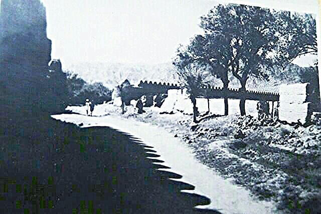
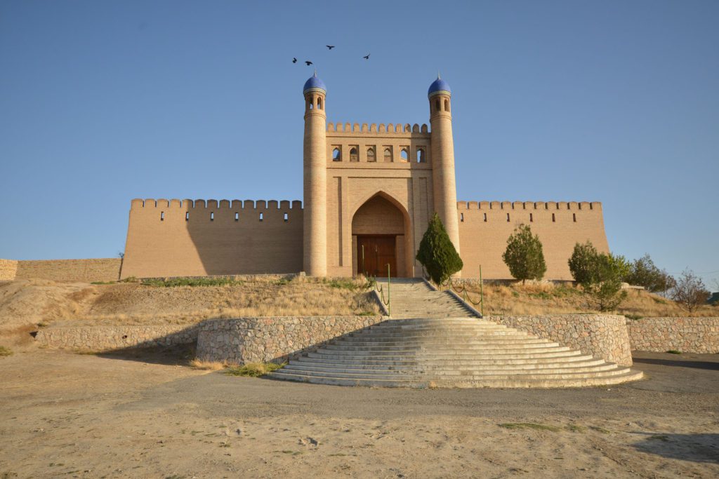
The history of the city goes into deep antiquity. Modern historical science believes that archaic Khujand existed during the Achaemenid dynasty, that is, before the troops of Alexander the Great came to the shores of the Syr Darya. Under the Achaemenids, the Khojent was the eastern outpost of the Persian Empire. The ancient Greek and Roman authors considered the Khujand the border of Asia. 2500 years ago, Alexander the Great set up his military camp at this place, calling the settlement “Alexandria Eskhata” (Alexandria Krainyaya). The ancient author Arian mentions that in 329 BC, on the orders of Alexander, the city was fortified with fortress walls. In 1975, at the cut of the wall, archaeologists discovered a fragment of ancient masonry dating from the 5th century BC, and the hole in the citadel, laid at a depth of 27 m, revealed layers of the 7th-5th centuries BC. The citadel of ancient Khojent is located on the shores of the Syr Darya, occupying an area of 320×200 m. The impregnable walls of it were repeatedly taken by assault by the troops of the Mayan caliphs, Turks, and the hordes of Genghis Khan. Ancient Khojent, supplied with water by five canals, had a fortified wall 10.5 km long with seven gates from which main streets led to the center. The Arabic speaking geographers of the 10th century have called the city a high epithet “Tyrosi Jahon” – “The Bride of Peace”. At the beginning of the twentieth century, the city still retained its oriental appearance and consisted of 146, united by related and professional features, neighborhoods that united around social and religious centers: 33 Friday and 121 Makhalin mosques, more than 100 houses, 37 caravanserais, 300 teahouse. Being a major handicraft and trade center, including silk weaving, the city had ancient scientific and cultural traditions. By the number of madrasahs, Khojent was second only to Bukhara and Samarkand and was home to more than 300 outstanding scholars, poets and musicians.
From ancient times, Khujand, being at the crossroads of trade routes of the East, was one of the most important economic, military, strategic and cultural centers of Maverannahr. The Great Silk Road passed through it, linking ancient Greece, Rome, Asia Minor, Egypt, Iran with India, China and Japan. Khujand was the birthplace of famous astronomers, mathematicians, doctors, historians, poets, and musicians. One of them is Abumahmud Khujandi – the founder of the local astronomical school, an outstanding authority of world science. In the XIV century, Kamoli Khujandi, the author of the famous ghazals, was called “the Nightingale of Khujand”. Equally popular in the Middle Ages was the eminent poetess, musician and dancer Makhasti. In the 19th century, such cultural figures as Toshkhoja Asiri, Sodirhon Hafiz, and Khoji Yusuf conducted active educational work in Khujand.
ISTARAVSHAN
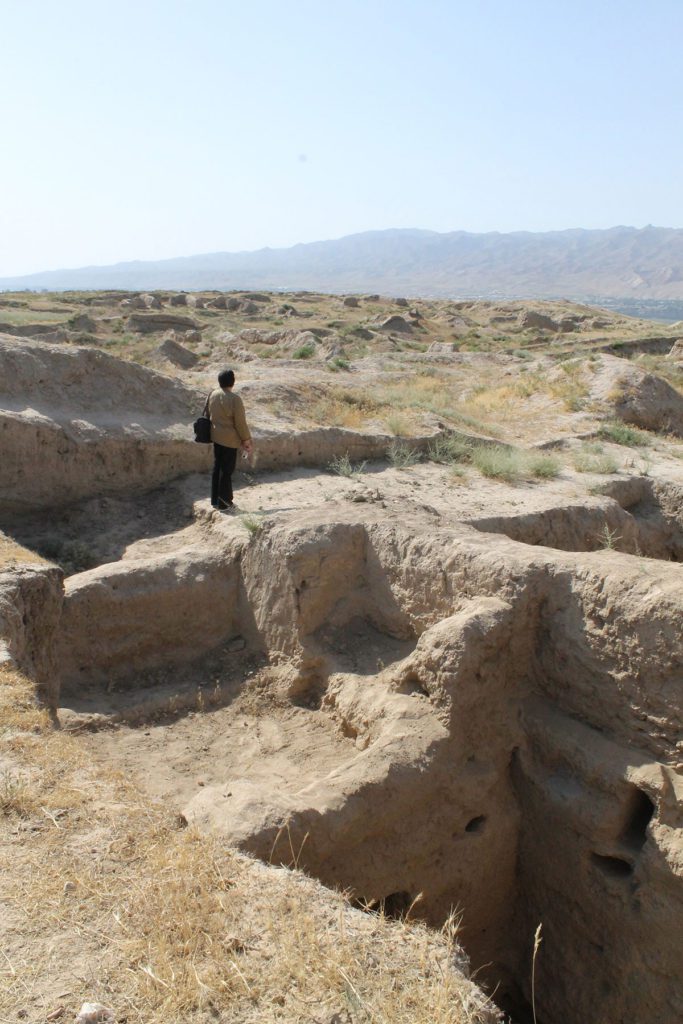
Istravshan is a town of crafts, one of the oldest cities in Central Asia, which celebrated its 2500th anniversary in 2002, is located 73 km from the city of Khojent. The Persians called this city Kurukada, Sogdians – Kurushkada. Modern scholars identify him with the ancient Kiropol, or, according to Ptolemy, with Kireshata.
In the VIth century BC the city was strengthened by three rows of walls, had a quotation surrounded by walls, the length of which was six thousand meters, famous for its crafts, skillful craftsmen and profitable bargains.
Some scholars believe that in the I-II century BC. and I-II in our era Istaravshan was known as Ustrushan and was part of the independent region of Ustrushan with the capital Bunjikat. It was an important commercial center, as the roads led from here to Khojent, Bukhara, Samarkand, the Fergana Valley.
In the years of Arab rule Istaravshan, and he became a province of the caliphate in 822, was widely known in the Muslim medieval East as a commercial and cultural center. Here, new types of architectural structures of Islam (mosque, melresa, mausoleum, minaret, etc.) developed. based on the development of portal-dome structures.
In the thirteenth century Istravshan’s progressive development was interrupted by the invasion of Chingis Khan’s troops in Central Asia, they began to plunder and exterminate the local population, as a result of which many of the settlements became ruins, the irrigation systems became useless, the cities became empty.
At the end of the XIV century. When the powerful Timurid empire with its capital in Samarkand and Maverannahr was experiencing an unprecedented flourishing, historical reports about the city reappeared, but now it was called Ura-Tyube.
The city is becoming one of the most populous, dynamic centers of the new state. Residential areas were expanded, the urban area was improved. The population was supplied with water through aryks, underground pipes, and wells.
In order to meet the water needs of local people, recreational areas with ponds and closed water reservoirs were created in each quarter.
In the 16th century, Maverannahr (in the place with it and Ura-Tyube) lost its importance and prestige as a result of the formation of a new state ruled by the Sheibanids dynasty, with the capital Bukhara. Transit trade from India
PENJIKENT
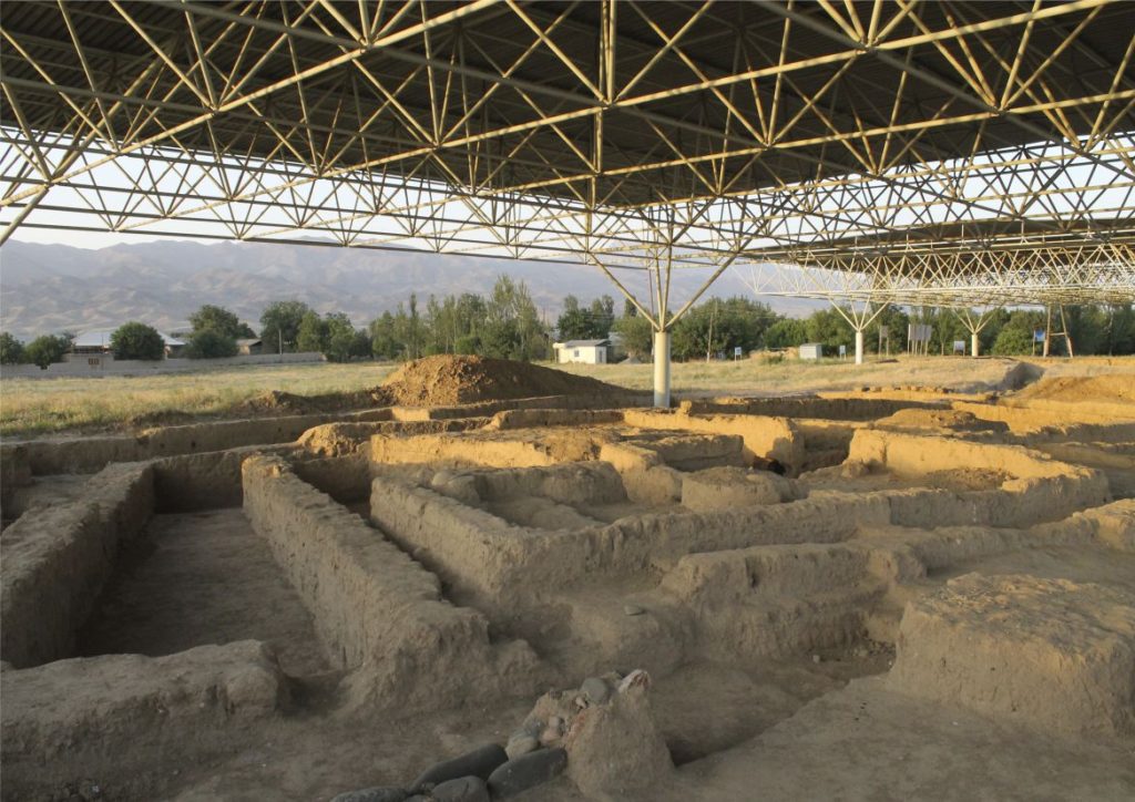
The ruins of ancient Penjikent attracted attention in the 19th century, but only in 1946 systematic archaeological excavations began here, which covered about half of the settlement. The citadel with the Divashtich palace, two temples with extensive courtyards in the center of the settlement, eight main streets and ten lanes, shops, workshops, bazaars, fortress walls, multi-room two- and even three-story dwellings were excavated. The contrast between the power of the architectural forms of the buildings and the modest building material — raw brick from unbaked clay from which they were erected — is striking. Each well-to-do owner decorated his house with wall painting and wooden sculpture.
SARAZM
The ancient monument of Sarazm was discovered in the fall of 1976 by archaeologist Abudlojon Iskhakov. The monument is located 15 km from the west of Panjikent and 45 km east of Samarkand. The original area of the monument was about 130 hectares. The settlement was intensively inhabited for more than a thousand years, it reached its greatest prosperity during the Late Aeneolithic and Early Bronze Age.
Four consecutive chronological periods are distinguished, which, taking into account radiocarbon analyzes, are dated as follows: period 1 – 3500-3200 BC; period 2 – 3200 – 2900 BC; period 3 – 2900-2700 BC; period 4 – 2700 – 2000 BC.
By the Decree of the Government of the Republic of Tajikistan dated 9/21/2001 under No. 391, the 5500 summer monument of Sarazm of the Pandzhakentsky district is declared a historical and archaeological reserve, as a center for shaping the culture of agriculture, handicrafts and urban planning of the Tajiks.
YAGNOBSKY VALLEY
The valley of the Yagnob River originates approximately 105 km north of the capital of Tajikistan, Dushanbe, just past the Anzob Pass (3372 m and has a length of about 60 km. The Jagnob is formed from the confluence of the Rev, bkm and Barzenga rivers, originating in the glaciers of the Takali mountain site The Yagnob River flows parallel to the Zeravshan River and separates the Zeravshan Range from the Gissar.
The upper part of the valley is famous for its alpine and subalpine meadows, but the population does not live here permanently. Only in summer do shepherds bring cattle to graze here.
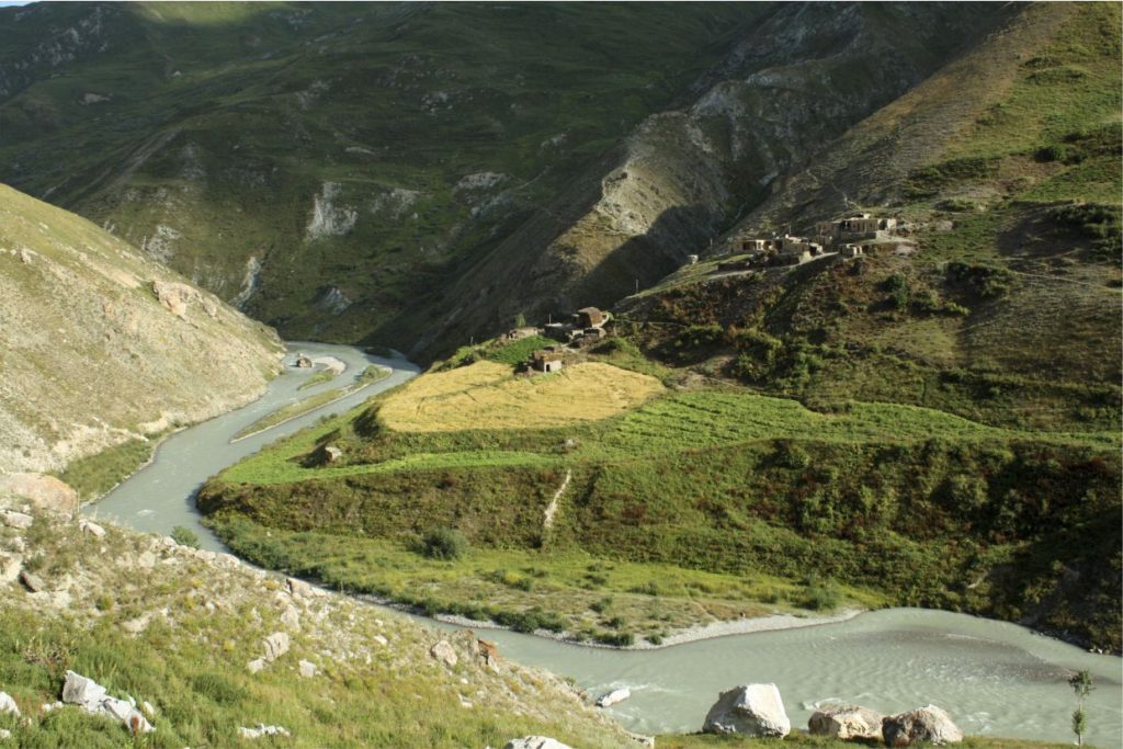
In the middle reaches of the river, where the valley is relatively wide and open, there are small villages, at altitudes of about 2-3 thousand meters, in which the Yagnobians live – a special group of Tajiks, direct descendants of the Sogdians. Their language is one of the little-studied dialects of the ancient Sogdian language. Representatives of some of the ancestors of the modern Tajiks spoke before the Arabs conquered in VII-VIII centuries of Central Asia Now yagnobtsy communicate in two languages - their own, belonging to the East Iranian group, and Tajik. Moreover, the Yagnob language is not understandable to many Tajiks. It is noteworthy that the “guardians” of the rare language are women, because in communication they prefer to speak their native language, unlike men, who prefer Tajik.
At the end of the 60s of the 20th century, the inhabitants of Yagnoba were resettled in the valleys to engage in cotton growing, and only after the collapse of the Soviet Union did the Yagnobians return to their homes for permanent residence.
Traditional dwellings in local villages (and there are more than 30 of them) are constructed of slate slabs and consist of numerous residential and business premises, often combined under one roof, where fuel and fodder stocks are kept. The ceiling is supported by carved beams: niches for household things are arranged in the walls. Stoves and fireplaces – an obligatory accessory of all residential premises.
Despite the fact that today гagnobians are adherents of the Muslim religion, they have retained some of the pre-Islamic views associated with the ancient pagan concepts, Zoroastrianism (fire worship). So, and now in Yagnob it is forbidden to blow fire with your mouth: many holidays are accompanied by jumping over the fire: the bride entering the groom’s house is greeted with a lighted lamp, first leading her around the fire. In some of the numerous mazars (holy places, shrines of the saints), the locals leave small ceramic animal figures – sheep, horses, mountain goats, which, according to legend, come alive at night. go down to the river and enter into combat with the spirits. If the next day it is found that the figure left by someone is broken, it means. that the saint did not accept the sacrifice
In one of the most ancient and revered places of Yagnob – mazar Hatti Mullo in the village of Sokan – a curious ritual is performed, during which a person passes around three times a stone, a building and a massive column, located on the territory of the mazar. And after each detour of the column polished to shine it is necessary to cling to it to clasp it with your hands so that the fingers do not close (the trunk of the column is supposedly thicker), then such a person can expect trouble …
Yagnob is of great interest not only for ethnographers or culturologists, but also for hikers in the mountains, climbers and climbers.
The Yagnob wall known by mountaineers is located here, which is called Zamina Karor by local residents (which means “Tranquil land” in Tajik), that is, a mountain that does not suffer from earthquakes and falls.
Zamin Karor stretches for 8 km in the latitudinal direction and has several separate peaks, located at a considerable distance from each other, of which the peak with the highest mark of 4767 m is in the eastern part.
The eastern part of the Zamin Karor massif has significant glaciation, and the western part is purely rocky. The average steepness of the northern walls of the array – from 60 degrees to a plumb line. The southern slopes are very smooth, relatively gentle.
The main climbing routes to the summit of the Zamin Karor massif are from the north, and they are accessible to well-trained and highly skilled climbers. The descent to the south is not difficult and goes on slabs and scree slopes.
The path to the Yagnob wall from the Dushanbe-Aini highway (the bridge over the Yagnob river, immediately after descending from the Anzob pass) takes about three hours.
An interesting attraction of the Yagnob gorge is the so-called “fossil forests” belonging to the Jurassic period. Fossilized wood in the form of huge trunks and stumps, branches, and horsetail bushes. There is an assumption that the climate of the Jurassic period in the valley of Yagnoba was the same as today on the southern coast of Australia and Tasmania, and there was lush vegetation, drying out, and partly – preservation in the thickness of sandy and clay-gravel sediments. For centuries, the preserved parts of plants were replaced only by the external structure of wood, but often also by growth rings. Petrified Yagnoba Trees